
How to Look Up Any Loudoun County Property: Records, GIS & Deed Search
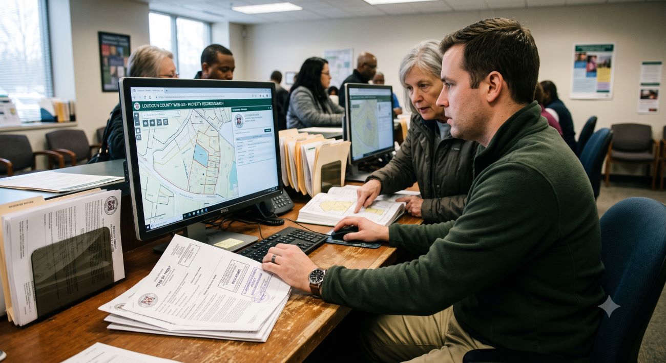
Every fact about a home in Loudoun County is sitting in a public database somewhere, who owns it, what it last sold for, its assessed value, its zoning, its exact property lines, even the building permits pulled on it decades ago. The catch is that these records live across four or five separate government systems, and most people never learn which tool answers which question.
This guide fixes that. As Loudoun County real estate specialists, The Jamil Brothers Realty Group pull these records every day, and below we walk you through each official tool, what it shows, and the exact steps to find any property fast and for free. Whether you are researching before you buy, checking a comparable sale, settling a boundary question, or getting ready to sell your Loudoun County home, this is your map. Working as a top-rated real estate team across the DMV, we also show you where the public record ends and where professional data takes over.
Quick Answer: To look up a Loudoun County property, start with the county's Real Estate Assessment and Parcel Database (loudoun.gov/parceldatabase) to find ownership, assessed value, and sales history by address. Use WebLogis, Loudoun's online mapping system, for property lines, zoning, flood zones, and aerial imagery. Use LandMARC to search building permits and land-development applications. For deeds and legal ownership documents, use the Clerk of the Circuit Court's Online Land Records. Index searches are free; you only pay if you download official deed images. Every one of these tools is public and available online.
Key Takeaways
- A handful of official tools cover everything: the Parcel Database, WebLogis, LandMARC, the Clerk's Online Land Records, GeoHub, and Pictometry.
- Search by address, owner name, or PIN: the parcel database and land records let you look up a property by the owner's name, not just the street address.
- Start with the address, then get the PIN: the Parcel Identification Number is the unique key that ties every system together.
- Ownership, value, and sales history all live in the Real Estate Assessment and Parcel Database, updated regularly.
- WebLogis shows the map layer: property lines, zoning, land use, flood, and aerial imagery for any parcel.
- Deeds live with the Circuit Court Clerk: index searches are free; document images carry a small fee.
- Public records lag the live market: assessments and closed sales tell you the past, not today's market value.
- An agent fills the gaps with current MLS data, pending sales, and true market value the public record cannot show.
On This Page
- What you can find in property records
- The 5 official Loudoun County tools
- How to look up a property, step by step
- Understanding the Parcel ID (PIN)
- Search by address, owner name, or PIN
- How to find out who owns a property
- How to do a deed search
- Reading assessment and sales history
- Zoning, flood, and land use on WebLogis
- How to find a plat map
- Building permits and property history
- What records can and can't tell you
- Frequently asked questions
- Glossary
What You Can Find in Loudoun County Property Records
Public property records are more detailed than most people expect. Before you open a single tool, it helps to know what is actually available, because that tells you which system to reach for. For any parcel in the county, you can typically pull the following.
| What You Want | Where It Lives |
|---|---|
| Current owner name | Real Estate Assessment & Parcel Database |
| Assessed value & tax history | Real Estate Assessment & Parcel Database |
| Sales / transfer history | Parcel Database + Clerk's Land Records |
| Deed & legal documents | Clerk of the Circuit Court, Online Land Records |
| Property lines & lot size | WebLogis mapping system |
| Zoning & land use | WebLogis mapping system |
| Flood zone & aerial imagery | WebLogis mapping system |
| Building permits | LandMARC |
| House characteristics (beds, baths, sq ft) | Real Estate Assessment & Parcel Database |
Pro tip: Almost every search starts with a street address, but the moment you have the property's PIN (Parcel Identification Number), use that instead. Similar street names and recent subdivisions cause address mix-ups; the PIN never does.
The Official Loudoun County Property Tools
Loudoun County publishes its records across a handful of free, public systems. Here is what each one does and where to find it, so you can jump straight to the right place.
Ownership · Value · Sales
Real Estate Assessment & Parcel Database
The county's official parcel database, also called Real Property Search (reparcelasmt.loudoun.gov). Look up a property by address, owner name, PIN, or Tax Map Number for ownership, assessed value, sales history, and house characteristics.
loudoun.gov/parceldatabase →Maps · Lines · Zoning
WebLogis Online Mapping
Loudoun's GIS mapping system. View property boundaries, lot size, zoning, planned land use, flood zones, and current aerial imagery for any parcel.
logis.loudoun.gov/weblogis →Permits · Applications
LandMARC
The county's land-management system. Search building permits, inspections, and land-development applications by address, no account needed for public records.
loudoun.gov/LandMARC →Deeds · Legal Records
Clerk's Online Land Records
The Circuit Court Clerk's remote-access system for deeds and recorded documents. Search the index free; pay only to view or download official images.
loudoun.gov/Clerk/OnlineLandRecords →Data · Downloads
Loudoun County GeoHub
The open-data portal for GIS datasets, interactive maps, and downloadable layers, useful for research across many parcels at once.
geohub-loudoungis.opendata.arcgis.com →Aerial · 3D Imagery
Pictometry
High-resolution oblique (angled) aerial imagery, so you can view a property from multiple directions, not just straight down. Accessible through the county's Property Information page.
loudoun.gov Property Information →Lot Maps · Subdivisions
Recorded Plats
The official subdivision and lot maps showing dimensions, easements, and boundaries. View them through WebLogis and the GeoHub, or pull the recorded version from the Clerk's Land Records.
Find plats & maps →Current Market Value
Free Home Valuation from The Jamil Brothers
Public records show the past. For what a home is worth today, get a free valuation built on live MLS comparable sales, no cost, no obligation.
Get my free valuation →Official vs. third-party sites: Search results often surface private property sites and data aggregators. They can be convenient, but the county's own systems above are the authoritative, free, and most current source, and they avoid the upsells and stale data some third-party sites carry. When accuracy matters, start with the official tools.
How to Look Up a Property, Step by Step
Here is the workflow we use to pull a full picture of any Loudoun County property. Follow it in order and you will have everything the public record holds in a few minutes.
Start with the address in the Parcel Database
Go to the Real Estate Assessment and Parcel Database and enter the street address. This returns the owner, the PIN, the assessed value, and the home's basic characteristics. Copy the PIN, you will reuse it everywhere.
Review assessment and sales history
On the parcel record, check the current and historical assessed values and the sales/transfer history. This shows what the property last sold for and when, along with prior assessments.
Open the parcel in WebLogis
Search the same address or PIN in WebLogis to see the property lines, exact lot size, zoning, planned land use, and aerial view. Toggle layers on and off to check flood zones and adjacent parcels.
Pull the deed from Online Land Records
In the Clerk's Online Land Records, search by owner name or document criteria to find the recorded deed. The index is free; download the official image if you need the legal document itself.
Check permits in LandMARC
Finally, search the address in LandMARC to see building permits and land-development history, useful for confirming an addition, a deck, or a finished basement was done with the proper approvals.
Understanding the Parcel ID (PIN)
The single most useful piece of data in the whole process is the Parcel Identification Number, or PIN. It is the county's unique fingerprint for a piece of land, and it does not change when the home is sold, so it is far more reliable than an address.
You will also encounter the Tax Map Number, a related identifier tied to the county's mapping grid. Either one lets you search across every system without ambiguity. Once you have pulled a property's PIN from the Parcel Database, use it in WebLogis and LandMARC to guarantee you are looking at the exact same parcel, not a similarly named lot two streets over.
Why it matters: In fast-growing areas like Ashburn, Aldie, and Brambleton, new subdivisions create clusters of near-identical addresses. Searching by PIN eliminates the risk of researching the wrong home, a mistake that can cost you in a purchase or an appraisal dispute.
Search by Address, Owner Name, or Parcel ID
The Real Property Search database gives you three ways in, and the right one depends on what you already know. All three return the same detailed parcel record.
| Search By | Best When |
|---|---|
| Address | You know where the property is; the everyday starting point. |
| Owner name | You know who owns it but not the address, or want every parcel a person or company owns. |
| Parcel ID (PIN) or Tax Map Number | You want a guaranteed exact match with no address confusion. |
Owner-name search is especially handy for tracking down a specific person's or LLC's holdings, or for a property-tax lookup by owner. Just note that common names can return multiple results, so confirm you have the right parcel by cross-checking the address or PIN.
How to Find Out Who Owns a Property in Loudoun County
This is the most common reason people search property records, and in Loudoun County it is refreshingly simple. Owner names are public information tied to the parcel.
The fastest route is the Real Estate Assessment and Parcel Database: enter the address, and the current owner of record appears alongside the assessment details. If you want the underlying legal proof of ownership, the recorded deed in the Clerk's Online Land Records names the grantor (seller) and grantee (buyer) and is the authoritative source.
Keep in mind that ownership listed in public records reflects the last recorded transfer, so a very recent sale may take a short time to appear. If a property is held in an LLC or a trust, the record will show that entity rather than an individual, which is common for investment properties and estate planning.
How to Do a Deed Search
A deed is the legal document that transfers ownership, and every deed in Loudoun County is recorded with the Clerk of the Circuit Court. The Clerk now offers online remote access, so you no longer have to visit the courthouse for most searches.
Using the Clerk's Online Land Records, you create a free account, then search the deed and land-record indices by name, document type, and date range at no charge. When you find the specific document you need, you pay a small fee only to view or download the official image. Searches can be run by grantor or grantee name, which is why a deed search is a reliable way to confirm ownership history.
If you would rather research in person or need certified copies, the Clerk's Land Records office is located at 18 East Market Street in Leesburg, and public research kiosks are available on site. You can reach the Land Records division at (703) 737-8775 to confirm current hours and copy fees before you go.
Good to know: A deed of trust is not the same as a deed. The deed transfers ownership; a deed of trust secures the mortgage loan against the property. Both are recorded in Land Records, so you may see several documents tied to a single purchase.
Reading Assessment and Sales History
The parcel record gives you two numbers that people constantly confuse: the assessed value and the last sale price. The assessed value is what the county uses to calculate property taxes, updated on an annual schedule. The sale price is what the home actually traded for on a specific date.
Neither of these is the same as what the property is worth today. In a market that has moved since the last assessment or the last sale, both figures can be well below current value. If you are trying to understand the gap, our full breakdown of assessed value vs. market value in Loudoun County explains exactly why the tax roll and the sale price rarely match today's market.
Sales history is still genuinely useful. A string of past transfers, the dates, and the prices help you understand how a property has appreciated and how long owners tend to hold. Just remember you are reading history, not a current appraisal. For a sense of how quickly homes are moving right now, see our guide on how long it takes to sell a home in Loudoun County.
Interactive · Commission Savings
Thinking of Selling? See What You Keep With a 1.5% Listing Fee
Pick your Loudoun home value:
Typical 3% Listing Fee
Your Estimated Savings
$6,000
Kept in your pocket versus a traditional 3% listing fee.
Typical 3% Listing Fee
Your Estimated Savings
$7,500
Kept in your pocket versus a traditional 3% listing fee.
Typical 3% Listing Fee
Your Estimated Savings
$9,000
Kept in your pocket versus a traditional 3% listing fee.
Typical 3% Listing Fee
Your Estimated Savings
$11,250
Kept in your pocket versus a traditional 3% listing fee.
Typical 3% Listing Fee
Your Estimated Savings
$15,000
Kept in your pocket versus a traditional 3% listing fee.
Estimates compare a 3% listing-side fee to our 1.5% listing fee. Full-service representation either way. Buyer's-agent commission is separate and negotiable.
Zoning, Flood, and Land Use on WebLogis
WebLogis is the visual half of property research. Where the Parcel Database gives you numbers, WebLogis gives you the map, and it answers questions that text records simply cannot.
Search a parcel and you can turn on layers to see the exact property boundaries and lot dimensions, the current zoning designation, the planned land use for the surrounding area, floodplain overlays, and up-to-date aerial imagery. This is how you confirm whether that wooded strip behind a home is part of the lot or a neighbor's, whether a parcel sits in a flood zone, or what could be built nearby.
- Property lines and lot size: verify boundaries before a purchase, a fence, or a dispute.
- Zoning and land use: understand what a property can legally be used for and what may be planned next door.
- Flood and environmental layers: check floodplain status that can affect insurance and value.
- Aerial imagery: see the actual footprint, driveways, outbuildings, and tree cover.
Heads up: WebLogis boundary lines are excellent for research but are not a substitute for a licensed survey. For a fence, an addition, or a legal boundary question, order a professional survey before you build.
How to Find a Plat Map
A plat is the official recorded map of a lot or subdivision, and it is the document that shows your exact lot dimensions, easements, setbacks, and boundary lines. It is more precise than the general parcel outline and is often what people are really after when they search for property lines.
In Loudoun County you can view plats through WebLogis and the GeoHub for the mapped version, and pull the recorded plat from the Clerk's Land Records when you need the official document. For a new subdivision, the recorded plat is the authoritative source for where one lot ends and the next begins.
Plat vs. survey: A recorded plat shows the subdivision as approved, but only a current licensed survey confirms the boundaries and improvements on the ground today. Use the plat for research and a survey for decisions like fences and additions.
Building Permits and Property History
LandMARC is Loudoun County's system for permits and land-development records, and you do not need an account to search public records. Enter an address and you can review the building permits pulled on a property, which tells a story the listing photos never will.
Permit history helps you confirm that a finished basement, an addition, a deck, or a major system replacement was completed with proper county approval and inspection. For buyers, unpermitted work is a genuine red flag that can create insurance and resale headaches later. For sellers, a clean permit trail is a selling point worth surfacing. If your goal is to boost value before listing, our guide on how to increase your home's value before selling covers which improvements actually pay off.
What Records Can and Can't Tell You
Public records are powerful, but they have real limits, and knowing them keeps you from drawing the wrong conclusion. Here is the honest picture.
| Public Records Show | Public Records Miss |
|---|---|
| Owner of record and legal documents | Current market value of the home today |
| Assessed value for taxes | Interior condition, updates, and finishes |
| Last recorded sale price and date | Pending sales and homes under contract now |
| Zoning, lot lines, and permits | Off-market and coming-soon inventory |
| Historical transfers | What buyers are actually paying this month |
In short, the public record is a rear-view mirror. It is authoritative on what has happened, but silent on the live market. That is exactly where a local agent's data takes over: full MLS access, pending and just-sold comparables, and a trained read on condition and demand. Choosing the right professional matters here, so it is worth knowing how to choose the best listing agent in Loudoun County before you rely on anyone's numbers.
Explore Loudoun Communities
Researching a Property in a Loudoun County Community?
Frequently Asked Questions
How do I look up property records in Loudoun County?
Start at the county's Real Estate Assessment and Parcel Database (loudoun.gov/parceldatabase) and search by address for the owner, assessed value, and sales history. Use WebLogis for maps, property lines, and zoning; LandMARC for building permits; and the Clerk of the Circuit Court's Online Land Records for deeds. All four are free to search online, and you only pay to download official deed images.
How do I find out who owns a property in Loudoun County?
The quickest way is the Real Estate Assessment and Parcel Database: enter the address and the current owner of record appears with the assessment details. For legal confirmation, the recorded deed in the Clerk's Online Land Records names the grantor and grantee. Note that properties held by an LLC or trust will show that entity rather than an individual.
What is WebLogis?
WebLogis is Loudoun County's online mapping, or GIS, system. It lets you view any parcel's property boundaries, lot size, zoning, planned land use, flood zones, and aerial imagery. It is the tool to use when you need the visual and geographic picture of a property rather than its ownership or tax numbers.
How do I search Loudoun County land records or deeds online?
Use the Clerk of the Circuit Court's Online Land Records remote-access system. Create a free account and search the deed index by name, document type, and date range at no charge. When you find the document you need, you pay a small fee only to view or download the official image. You can also research in person at the Clerk's office in Leesburg.
Is Loudoun County property information free?
Yes, for the most part. Searching the Parcel Database, WebLogis, LandMARC, and the land-records index costs nothing. The only common charge is a small per-document fee if you choose to view or download an official copy of a recorded deed or land record from the Clerk's system.
What is a Parcel ID Number (PIN)?
The Parcel Identification Number is the county's unique identifier for a specific piece of land. Unlike an address, it does not change when a home is sold, which makes it the most reliable way to search across systems. Pull the PIN from the Parcel Database, then reuse it in WebLogis and LandMARC to be sure you are looking at the exact same parcel.
How do I find a property's assessed value and sales history?
Both live in the Real Estate Assessment and Parcel Database. Search the address to see current and historical assessed values along with the recorded sales and transfer history. Remember that the assessed value is a tax figure and the last sale price is historical; neither necessarily equals what the home is worth in today's market.
Can I look up building permits on a Loudoun County property?
Yes. Use LandMARC, the county's land-management system, and search by address to see building permits and land-development records. No account is needed for public records. Permit history is useful for confirming that additions, finished basements, or major upgrades were done with proper county approval and inspection.
How do I find property lines or zoning for a parcel?
Open the parcel in WebLogis and turn on the boundary, lot-dimension, and zoning layers. You can also view planned land use and aerial imagery. WebLogis is excellent for research, but its lines are not a legal survey; for a fence, an addition, or a boundary dispute, order a licensed survey.
Do property records show what a home will sell for?
No. Records show the assessed value and the last recorded sale price, both of which are backward-looking. In a market that has moved, current value can differ significantly from either number. To estimate what a home is worth today, you need a comparative market analysis built on recent and pending comparable sales, which is not part of the public record.
How current is Loudoun County property data?
The parcel and assessment data is updated on a regular schedule, and recorded documents appear after they are processed, so a very recent sale or transfer may take a short time to show up. Assessments update annually. For the most current market activity, including pending sales, you need live MLS data that the public systems do not carry.
Can I search Loudoun County property records by owner name?
Yes. The county's Real Property Search lets you look up parcels by owner name, not just by address, which is useful when you know who owns a property but not its address, or when you want to see every parcel a person or company owns. Common names may return several results, so confirm the right property by checking the address or Parcel ID.
How do I find the owner of a property in Virginia?
Ownership records in Virginia are kept at the county or city level, so you use the local jurisdiction's system. In Loudoun County, use the Real Estate Assessment and Parcel Database for the current owner and the Clerk of the Circuit Court's land records for the recorded deed. Other Virginia localities offer similar online assessment and land-record tools.
How do I find a plat map for a Loudoun County property?
View the mapped plat through WebLogis or the county GeoHub, and pull the official recorded plat from the Clerk's Land Records when you need the document itself. A plat shows lot dimensions, easements, and boundaries as recorded, though only a current licensed survey confirms the boundaries on the ground.
Glossary
Parcel ID Number (PIN): The county's unique identifier for a piece of land; the most reliable key for searching across every records system.
Tax Map Number: An identifier tied to the county's mapping grid, used alongside or in place of the PIN to locate a parcel.
WebLogis: Loudoun County's online GIS mapping system for property lines, zoning, land use, flood zones, and aerial imagery.
LandMARC: The county's land-management system for searching building permits and land-development applications.
Deed: The legal document that transfers ownership of real property; recorded with the Clerk of the Circuit Court.
Grantor & Grantee: The grantor is the party transferring the property (usually the seller); the grantee is the party receiving it (the buyer).
Deed of Trust: A recorded document that secures a mortgage loan against the property; distinct from the deed that transfers ownership.
Land Records: The Circuit Court Clerk's collection of recorded documents, including deeds, deeds of trust, plats, and liens.
Plat: The official recorded map of a lot or subdivision, showing dimensions, easements, and boundaries; more precise than the general parcel outline.
Pictometry: High-resolution oblique (angled) aerial imagery that lets you view a property from multiple directions, available through the county's mapping resources.
The Bottom Line on Looking Up Loudoun County Property Records
Almost everything you want to know about a Loudoun County property is public, free, and online. Start with the Parcel Database for ownership, value, and sales history, use WebLogis for the map, LandMARC for permits, and the Clerk's Online Land Records for deeds. Grab the PIN early and reuse it, and you can research any parcel like a professional in minutes.
Just remember what the record cannot tell you: what a home is worth today. Assessments and old sale prices look backward, while real value is set by the live market. When you are ready to turn research into a decision, whether buying, selling, or simply curious what your own home would fetch, that is where we come in.
Public data tells you the past. We will tell you what your Loudoun County home is worth right now, using live comparable sales, then show you how a 1.5% full-service listing keeps thousands more of your equity. Free, no obligation.
Disclaimer: This article is an independent educational guide for informational purposes only and is not legal, financial, or professional advice. Loudoun County systems, website addresses, fees, office hours, and procedures are maintained by Loudoun County and change over time; always verify current details directly with the county, the Office of the Commissioner of the Revenue, or the Clerk of the Circuit Court. The Jamil Brothers Realty Group is not affiliated with Loudoun County. GIS and mapping data are for reference only and are not a substitute for a licensed survey. The Jamil Brothers Realty Group is a licensed real estate team with Samson Properties serving Loudoun County and the greater DMV. Equal Housing Opportunity.
Explore More
Browse Every Corner of the DMV Market
Whether you're searching by budget, neighborhood, or buying situation — find exactly what you need below.
Virginia Homes by Budget
Washington DC Homes by Budget
Maryland Homes
Explore Fairfax County & Surrounding Northern Virginia
Ready to Make a Move?
Full-Service · No Tradeoffs
List for 1.5% & Keep More Equity
Professional photography, drone video, 3D tours, and expert negotiation — all included. On an $800K home, that's $12,000 more in your pocket vs. a 3% agent.
See the 1.5% Program →Need Speed or Certainty?
Get a No-Obligation Cash Offer
Skip the showings, skip the contingencies. If timing or condition matters more than top dollar, a cash offer may be the right fit. We'll walk you through every option.
Explore Cash Offers →
Categories
- All Blogs (1227)
- Aldie (3)
- Ashburn (6)
- Buyer Guide (8)
- Buying a home (2)
- Buying Strategies (30)
- festivals (1)
- General Blog (67)
- Leesburg (5)
- Market Intelligence (29)
- Market Updates (8)
- Notable Properties For Sale (32)
- Real Estate Tips, News, and More (385)
- Seller Guide (2)
- Seller Guides (60)
- Selling Your Home (522)
- Sterling (6)
- Top Realtors in Northern Virginia (58)
Recent Posts



Message Sent!
Thank you for reaching out. Arslan & Saad have received your details and will be in touch shortly.
Need immediate assistance? Call or text 703-782-4830.